Résultats
Nous avons trouvé 94 éléments semblables.


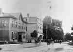
- Baldwin Street looking north from Campbell Street
 A black and white photograph of Baldwin Street looking north from Campbell Street. At left is the Brooklin Hotel (located at the north west corner of Baldwin and Campbell Streets). The white building beside it is the T.J. Holliday grocery and dry-goods store. At right is a bridge over Lynde …
  A black and white photograph of Baldwin Street looking north from Campbell Street. At left is the Brooklin Hotel (located at the north west corner of Baldwin and Campbell Streets). …Whitby Public Library
 - Baldwin Street looking north from Roebuck Street
 A black and white photograph of Baldwin Street looking north from Roebuck Street. Stores and shops in downtown Brooklin can be seen. At right ist he Brooklin Hardware Store (located at the north east corner of Baldwin and Roebuck Streets). The brick store at left is A.C. Elliott's grocery store …
  A black and white photograph of Baldwin Street looking north from Roebuck Street. Stores and shops in downtown Brooklin can be seen. At right ist he Brooklin Hardware Store (located …Whitby Public Library
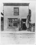
 - T.J. Holliday Store
 T.J. Holliday's store was located at 58 Baldwin Street (on the west side of Baldwin Street north of the Brooklin Hotel). The Holliday store operated from c.1878 to 1912.
  T.J. Holliday's store was located at 58 Baldwin Street (on the west side of Baldwin Street north of the Brooklin Hotel). The Holliday store operated from c.1878 to 1912.Whitby Public Library
 - Kay Irwin driving a horse drawn wagon at Brooklin Spring Fair
 The Brooklin Spring Fair was held in the community park south of Winchester Street.
  The Brooklin Spring Fair was held in the community park south of Winchester Street.Whitby Public Library
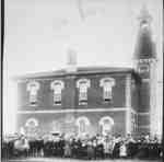
 - Brooklin Public School and Bell Tower, 1907

 The Brooklin School was built in the early 1870s at 72 Winchester Road East (on the north side of Winchester Road west of Queen Street). An addition was put on the east side in 1880. The school's bell tower was blown down in a storm and replaced by another tower …
 The Brooklin School was built in the early 1870s at 72 Winchester Road East (on the north side of Winchester Road west of Queen Street). An addition was put on …Whitby Public Library
 - Brooklin Public School, c.1906
 The Brooklin School was built in the early 1870s at 72 Winchester Road East (on the north side of Winchester Street west of Queen Street). An addition was put on the east side in 1880. The school's bell tower was blown down in a storm and replaced by another tower …
  The Brooklin School was built in the early 1870s at 72 Winchester Road East (on the north side of Winchester Street west of Queen Street). An addition was put on …Whitby Public Library
 - A.C. Elliott Store
 A.C. Elliott's Store was located at 50 Baldwin Street (at the south west corner of Baldwin and Campbell Streets). It was demolished in 1971 for the construction of the Bank of Commerce. The brick residence behind the store at right was built sometime between 1903 and 1910.
  A.C. Elliott's Store was located at 50 Baldwin Street (at the south west corner of Baldwin and Campbell Streets). It was demolished in 1971 for the construction of the Bank …Whitby Public Library
 - A.C. Elliott Store
 A.C. Elliott's Store was located at 50 Baldwin Street (at the south west corner of Baldwin and Campbell Streets). It was demolished in 1971 for the construction of the Bank of Commerce. The brick residence behind the store at right was built sometime between 1903 and 1910.
  A.C. Elliott's Store was located at 50 Baldwin Street (at the south west corner of Baldwin and Campbell Streets). It was demolished in 1971 for the construction of the Bank …Whitby Public Library
 - Brooklin looking north west from Church Street
 The mill was built in 1848. The Masonic Hall was built in 1871 on the north side of Mill Street (Cassels Road). The Methodist Church was built in 1867 at the south east corner of Mill and Princess Streets.
  The mill was built in 1848. The Masonic Hall was built in 1871 on the north side of Mill Street (Cassels Road). The Methodist Church was built in 1867 at …Whitby Public Library
 - Store on Baldwin Street in Brooklin

 This store was located at 65 Baldwin Street in Brooklin (on the east side of Baldwin Street about where Short's Pharmacy was located in 1980). The store building was demolished in the 1960s.
 This store was located at 65 Baldwin Street in Brooklin (on the east side of Baldwin Street about where Short's Pharmacy was located in 1980). The store building was demolished …Whitby Public Library
 - Store of J.C. Allems Harness Maker
 This store was located at 53 Baldwin Street (on the east side of Baldwin Street opposite Campbell Street). This building was later covered with brick. It was demolished in July 1980.
  This store was located at 53 Baldwin Street (on the east side of Baldwin Street opposite Campbell Street). This building was later covered with brick. It was demolished in July …Whitby Public Library
 - Residence of David Burns, c.1920
 This house was located at 110 Baldwin Street. It was built in 1892 by Fred Holliday on Lot 58, Perry's Plan. It was the residence of Brooklin poet David Burns (1850-1922).Whitby’s house numbering system was provided by Rev. Dr. James Roy Van Wyck (1877-1941), a retired Presbyterian minister. Van Wyck …
  This house was located at 110 Baldwin Street. It was built in 1892 by Fred Holliday on Lot 58, Perry's Plan. It was the residence of Brooklin poet David Burns …Whitby Public Library
 - Brooklin Baptist Church
 This church was located at 45 Cassels Road East at the south west corner of Cassels Road and Church Street. It was built as a Bible Christian Church in 1876. From 1884 to 1916 it was a Baptist Church. From 1920 to 1965 it was the Whitby Township hall and …
  This church was located at 45 Cassels Road East at the south west corner of Cassels Road and Church Street. It was built as a Bible Christian Church in 1876. …Whitby Public Library
 - Residence of Bishop Philander Smith
 This house was located at 33 Queen Street. It was the first brick house constructed in Brooklin. This cottage style house was built in 1857 for Rev. Philander Smith, Bishop of the Methodist Episcopal Church of Canada, by subscription from members of the church across Canada to replace his former …
  This house was located at 33 Queen Street. It was the first brick house constructed in Brooklin. This cottage style house was built in 1857 for Rev. Philander Smith, Bishop …Whitby Public Library
 - W.J. Haycraft Butcher Shop
 Haycraft's butcher shop was located at 46 Baldwin Street (part of lot 60, Campbell and Way Plan, west side of Baldwin Street). It was operated by William John Haycraft from before 1903 until he retired in 1912. In the 1940s this building was a Dominion Bank branch and was a …
  Haycraft's butcher shop was located at 46 Baldwin Street (part of lot 60, Campbell and Way Plan, west side of Baldwin Street). It was operated by William John Haycraft from …Whitby Public Library
 - Brooklin Public School, c.1889
 The Brooklin School was built in the early 1870s at 72 Winchester Road East (on the north side of Winchester Street west of Queen Street). An addition was put on the east side in 1880. The school's bell tower was blown down in a storm and replaced by another tower …
  The Brooklin School was built in the early 1870s at 72 Winchester Road East (on the north side of Winchester Street west of Queen Street). An addition was put on …Whitby Public Library
 - Residence of Frank A. Luke, c.1910-1911
 This house was located at 85 Baldwin Street (north of Lynde Creek on the east side of the road).Whitby’s house numbering system was provided by Rev. Dr. James Roy Van Wyck (1877-1941), a retired Presbyterian minister. Van Wyck provided this service to the town, free of charge, during the Great …
  This house was located at 85 Baldwin Street (north of Lynde Creek on the east side of the road).Whitby’s house numbering system was provided by Rev. Dr. James Roy Van …Whitby Public Library
 - Highway 12 looking south from Colston Street, c.1906
 The Brooklin Cheese Factory was located at the south west corner of Highway 12 and Colston Street. The building has since been demolished.Whitby’s house numbering system was provided by Rev. Dr. James Roy Van Wyck (1877-1941), a retired Presbyterian minister. Van Wyck provided this service to the town, free of …
  The Brooklin Cheese Factory was located at the south west corner of Highway 12 and Colston Street. The building has since been demolished.Whitby’s house numbering system was provided by Rev. …Whitby Public Library
 - Bridge over Lynde Creek
 A black and white photograph of the Highway 12 bridge over Lynde Creek. In the background is a large brick house north west of the bridge.
  A black and white photograph of the Highway 12 bridge over Lynde Creek. In the background is a large brick house north west of the bridge.Whitby Public Library
 - St. Thomas Anglican Church
 St. Thomas Anglican Church building was located at 101 Winchester Road East. It was built in 1869 on the south east corner of Anderson Street and Winchester Road.
  St. Thomas Anglican Church building was located at 101 Winchester Road East. It was built in 1869 on the south east corner of Anderson Street and Winchester Road.Whitby Public Library


