Résultats
Nous avons trouvé 2 éléments semblables.


Page 1 de 1
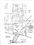
- Map of Brant's Block, later Wellington Square, and neighbouring properties, after a Plan drawn in 1817
 The road running north(west) between Augustus Bates's property and James Gage's property is now Brant Street. The road running north(west) between George Chisholm's lot and the portion of Brant's Block belonging to his heir, John Brant, is now Allview Avenue and Francis Road. The circular point, at the shoreline of …
  The road running north(west) between Augustus Bates's property and James Gage's property is now Brant Street. The road running north(west) between George Chisholm's lot and the portion of Brant's Block …Burlington Historical Society
 - Plan of the Township of Grantham and Louth 1814
 A copy of a map from the National Archives.
  A copy of a map from the National Archives.St. Catharines Museum
Page 1 de 1


