Résultats
Nous avons trouvé 2 éléments semblables.


Page 1 de 1
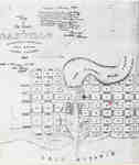
- Map of Oakville 1837
 The Drawing has been prepared from information gathered from a copy of the first registered plan of Oakville, by Deputy Provincial Surveyor, Robert W. Kerr in 1836, under the direction of Col. William Chisholm, the founder of Oakville. The Plan was registered January 12th 1850. James Madill, Oakville, 1973
  The Drawing has been prepared from information gathered from a copy of the first registered plan of Oakville, by Deputy Provincial Surveyor, Robert W. Kerr in 1836, under the direction …Oakville Public Library
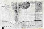
 - Plan of Oakville, Township of Trafalgar, Upper Canada, 1835
 A map from 1835 showing the town of Oakville from Brock Street to Allan Street, including the Sixteen Mile Creek. This map features the church, market square, wharf and an intended damn site north of the Colborne Street bridge.
  A map from 1835 showing the town of Oakville from Brock Street to Allan Street, including the Sixteen Mile Creek. This map features the church, market square, wharf and an …Oakville Public Library
Page 1 de 1


